Est. 2005 · UK-wide trenchless installations07920 553 578·chris@swdd.co.uk
Design, Survey & Support
Measured aerial surveys flown with RTK survey drones, backed by ground control from our own GPS and total station, with a ground survey to fill in what a drone can't see. Ideal for ground we can't safely walk.
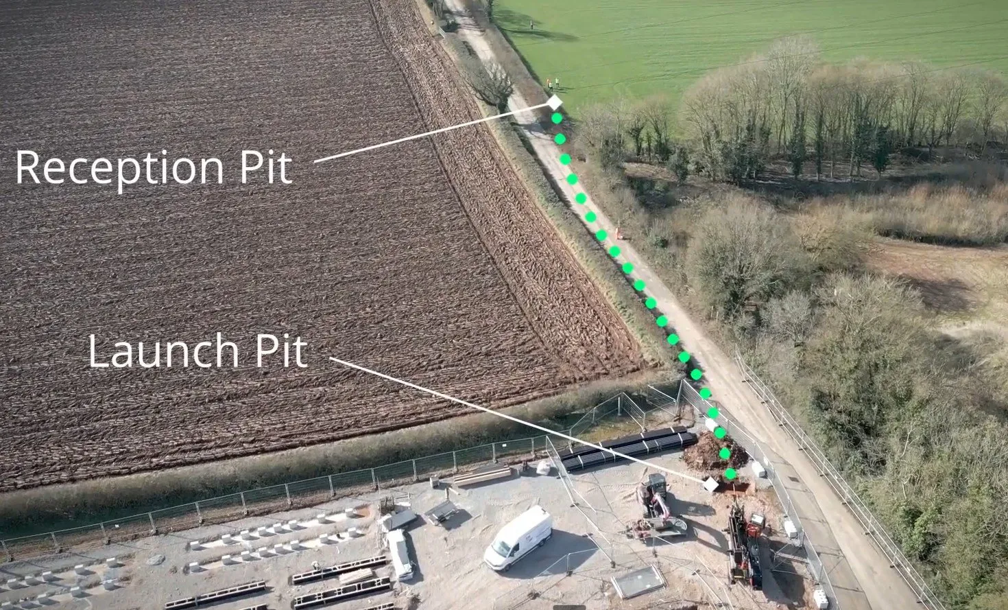
A drone gets the whole job in view fast. We fly the route corridor with an RTK (real-time kinematic) survey drone, tie it to ground control on the ground, and turn it into a measured survey accurate enough to design the bore against. We pick up the levels across the site and build the orthomosaics, and the same flight gives a clean pre-works record and an as-built once the crossing is in.
We back the aerial survey up with points on the ground, picked up with our own GPS and total station, which ties the survey in and checks it. The two work together. The drone covers ground we can't safely reach on foot, like live National Highways and Network Rail, and the ground survey fills in what the drone can't see from above, such as anything under tree cover. Where a site is heavily wooded we can also use our LiDAR survey drone, whose laser reads the ground through gaps in the canopy that a camera cannot.
For survey work we run the DJI Matrice series with RTK, so the drone fixes its own position precisely on every shot. For site video, inspection and progress records we use standard DJI Mini and DJI Mavic drones. It is a safe, quick way to capture riverbanks, embankments and live carriageway verges that are awkward or unsafe to walk, often without a road closure.
Drone capability
| Survey drones | DJI Matrice series with RTK positioning |
|---|---|
| Ground control | Check points picked up with our own GPS & total station, tied to OS grid & datum |
| Under tree cover | A ground survey fills in, or our LiDAR drone reads through the canopy |
| Survey outputs | Orthomosaic, point cloud, surface model & contours |
| Video drones | DJI Mini & DJI Mavic series for site footage |
| Best for | Access-restricted ground like National Highways & Network Rail |
| Coverage | UK-wide |
Survey-grade outputs come from the RTK drones and ground control. The Mini and Mavic drones cover video and inspection.
See it in action
This short film of our Iron Acton cable-duct crossing was shot with the video drone. There is more on the Iron Acton case study.
Questions answered
It captures the whole route corridor quickly and safely from the air, then turns it into a measured survey. We fly the line with an RTK survey drone and tie it to ground control points, so the outputs are accurate enough to design the bore against. It also gives us a clean pre-works record of the site and an as-built afterwards, which is useful for the design, for the client and for anyone working near the route later.
With RTK positioning and ground control tied to the OS grid and datum, the survey is accurate to centimetre level for the outputs that need it. The drone fixes its own position precisely on every shot, and the points we pick up on the ground with our own GPS and total station check and tie the whole survey in. For anything safety-critical we still confirm the key levels on the ground.
Yes. Alongside the DJI Matrice survey drones we run standard DJI Mini and DJI Mavic drones for site video and photography. That covers progress records, inspection of awkward or unsafe-to-reach areas like riverbanks and embankments, and footage for tenders and marketing. The film on this page, from our Iron Acton crossing, was shot with the video drone.
Yes, in two ways. Our own RTK survey drone photographs the open ground from above but cannot see through tree canopy, so where that matters we fill those areas in with a ground survey using our own GPS and total station and tie the two together into one survey. For dense vegetation or continuous canopy we can also use our LiDAR survey drone, whose laser finds the ground through gaps in the cover that a camera and satellites cannot. Either way you get full coverage of the corridor, not just the parts seen from the air.
That is one of the best reasons to use a drone. Live National Highways and Network Rail crossings, river crossings, steep embankments and large open sites can all be surveyed or filmed from the air without putting people in awkward or dangerous positions, and often without a road closure. We bring the survey back to the same control as a ground survey, so it still ties into the bore design.
Related services
Tell us the site and what you need, a measured survey, a pre-works record or progress footage, and we'll fly it and tie it into the design.