Est. 2005 · UK-wide trenchless installations07920 553 578·chris@swdd.co.uk
Case Study · River Crossing
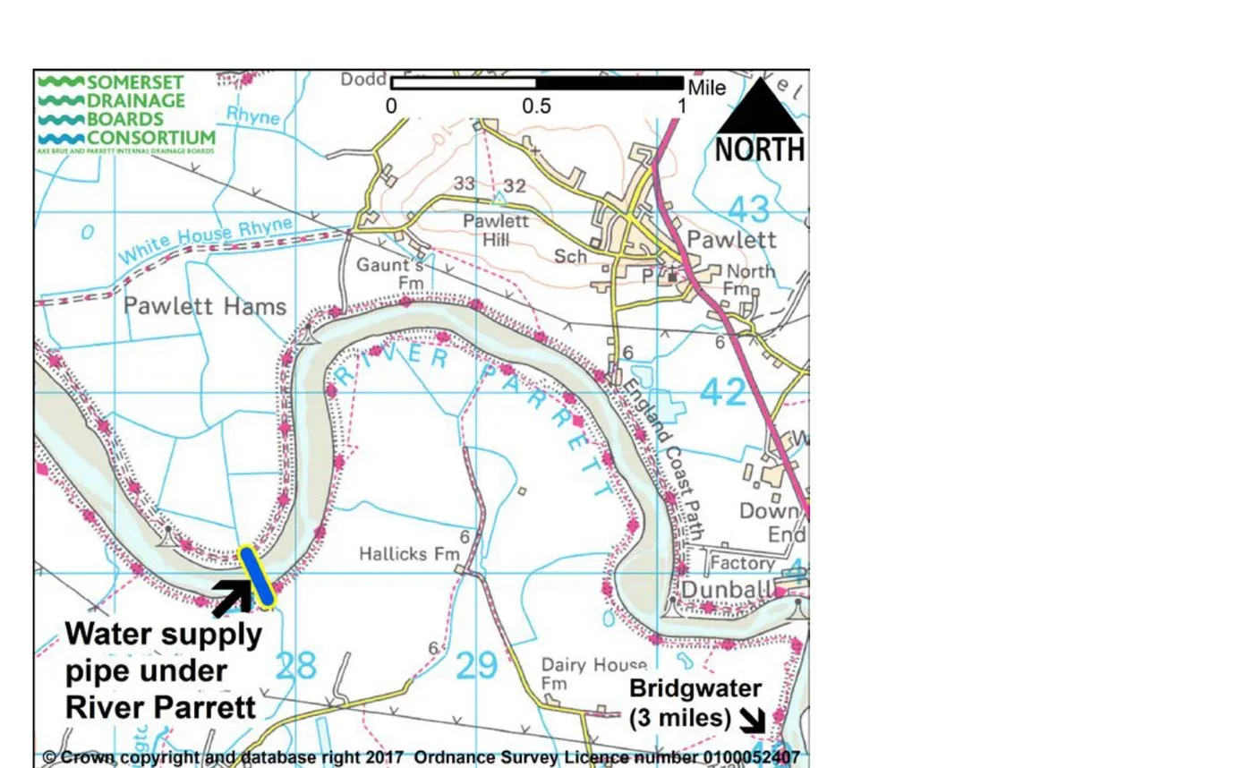
At Pawlett Hams near Bridgwater, we drilled a 252 metre water main clean under the tidal River Parrett, through clay and rock, to restore freshwater to a rare Somerset grazing marsh. One of the longest river crossings drilled in the South West, delivered in about four days with no impact to the river.
The job
Pawlett Hams is a stretch of rare coastal grazing marsh on the Somerset Levels, laced with the drainage ditches that keep it healthy. The job came down to a simple problem. The ditch on the far side of the River Parrett had water, the ditch on the Hams side had run dry, and the old ductile-iron main that linked the two across the river had been destroyed by high tides in 2015. With it gone, the marsh was left dangerously short of water for its grazing cattle and its wildlife. The Parrett Drainage Board needed a new pipe across the river that would actually last.
The catch is the river. The Parrett here is a wide, tidal, salt-water estuary, and the land each side is protected marsh. Digging a trench across it, or hanging a pipe off a bridge, was never on. So the Board and their consultant engineer, Clive Onions, brought us in to drill it. We worked up the crossing design with Clive, then delivered the work for the Board.
The answer was to steer a new main several metres below the riverbed, from a pit on one bank to a pit on the other, leaving the river and the marsh untouched.
Project at a glance
| Worked for | The Parrett Drainage Board (Somerset Drainage Boards Consortium) |
|---|---|
| Consultant engineer | Clive Onions, who we developed the crossing design with |
| Location | Pawlett Hams, near Combwich and Bridgwater, Somerset |
| Crossing | Under the tidal River Parrett, bank to bank |
| Pipe | 252m of 355mm HDPE water main, supplied, butt-fusion welded and de-beaded |
| Bore | Single pilot bore reamed to ~530mm, with a launch and reception pit, one on each bank |
| Groundworks | We excavated the launch and reception pits on each bank and managed the drilling spoil ourselves |
| Depth | Around 5m beneath the riverbed at the lowest point |
| Ground | A mixture of clay and rock, under a tidal estuary |
| Programme | Pilot bore started Tue 1 Aug, pipe installed by Fri 4 Aug 2017 (about four days) |
| Purpose | Replaced a water main destroyed by high tides in 2015, restoring freshwater to the grazing marsh |
| Setting | Pawlett Hams: 397ha of rare coastal grazing marsh, part of the Bridgwater Bay SSSI |
| Outcome | Completed on budget, one of the longest river crossings drilled in the South West |
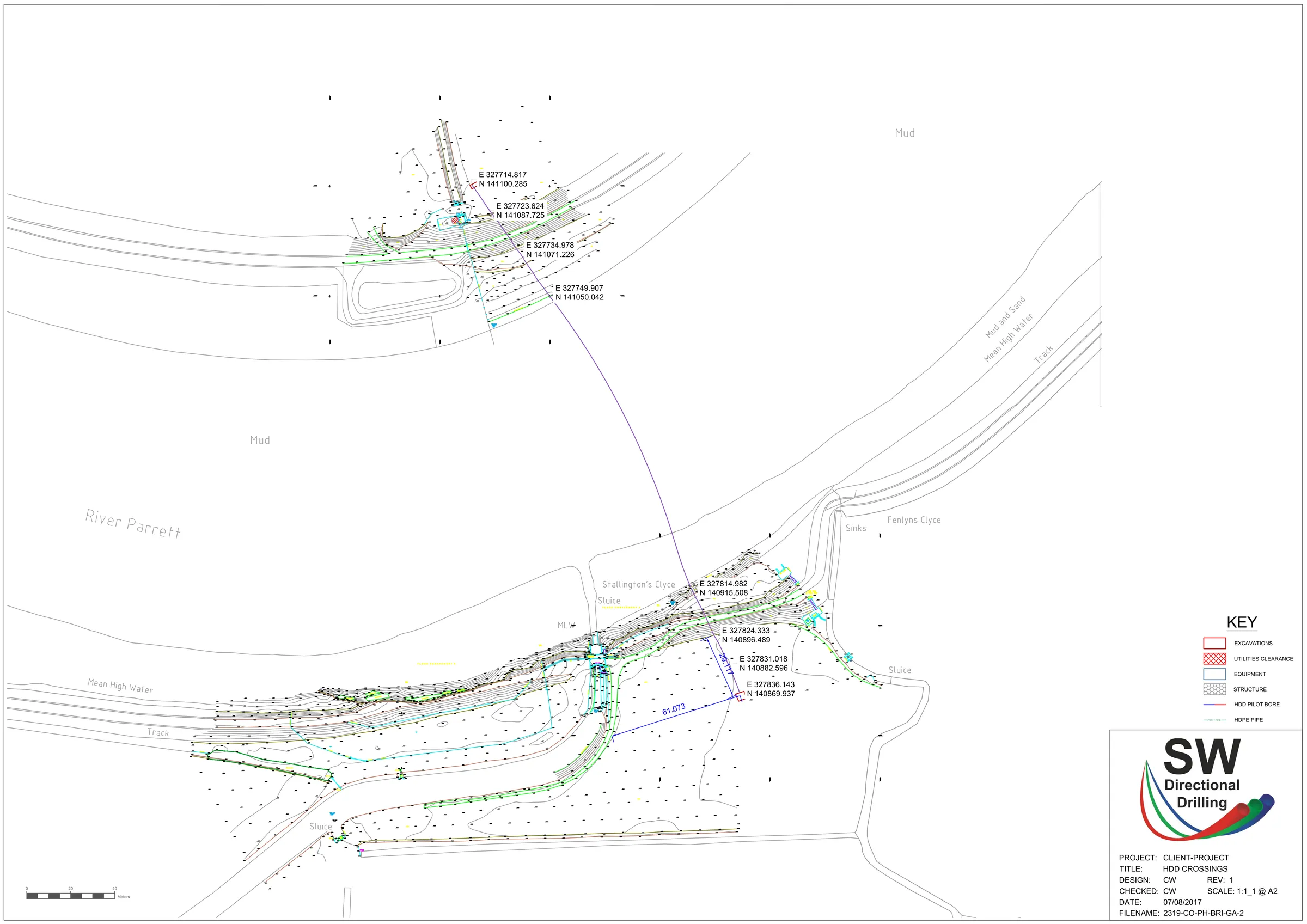
Our general arrangement, designed and checked in-house.
The crossing
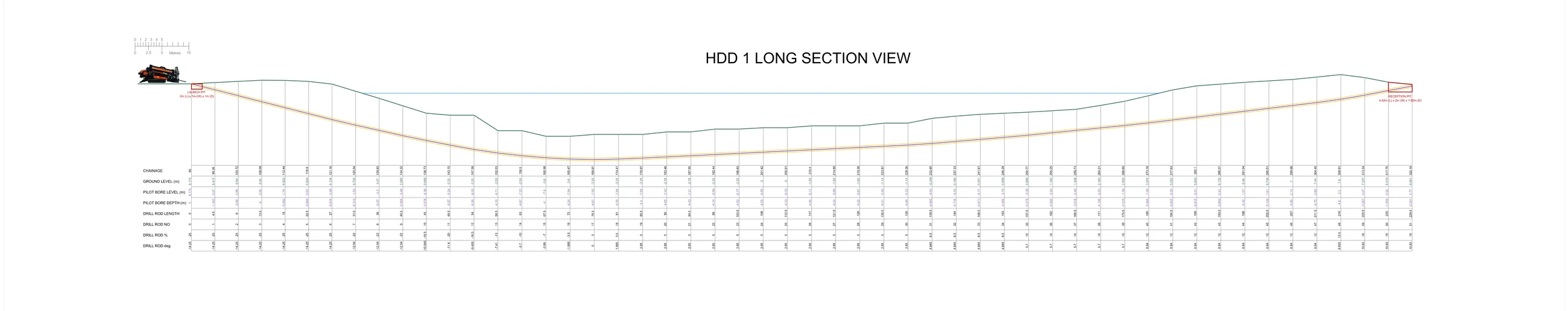
We installed 252 metres of 355mm HDPE water main under the river in a single continuous length. The pipe was supplied, butt-fusion welded into one string on the bank and de-beaded, taking the internal weld bead back out of each joint so the bore stays clean and the main can be pressure-cleaned with a foam pig in years to come.
The crossing did not start out this way. The original design ran the whole route as one longer bore. We reworked it into two shorter drills between the same start and end points. One is this bore under the river, the other a drill across the field beyond it that made up the rest. Keeping each individual crossing shorter takes risk out of the job and usually keeps the cost down too, so two shorter, well-controlled bores often beat one long pull, especially on a job that matters this much.
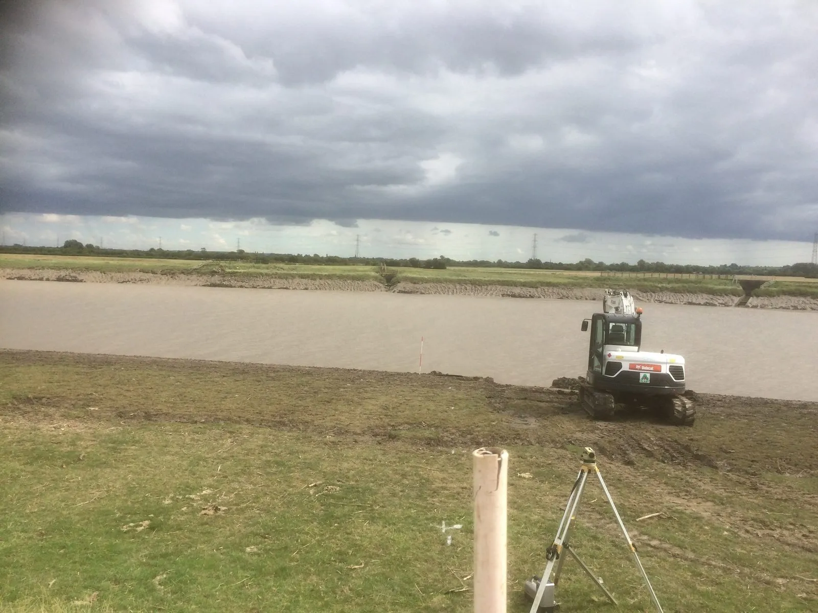
The pilot bore was steered from a launch pit on one bank, dipping down to around 5 metres beneath the riverbed at its lowest, then back up to a reception pit on the far bank. It ran through a mixture of clay and rock, the kind of mixed ground that decides which tooling you reach for. We then reamed the bore out to about 530mm and pulled the welded main through.
The groundwork on each bank was ours too. We excavated the launch and reception pits on both sides of the river and managed the drilling spoil ourselves, working the sites between the tides on the soft ground of the Hams.
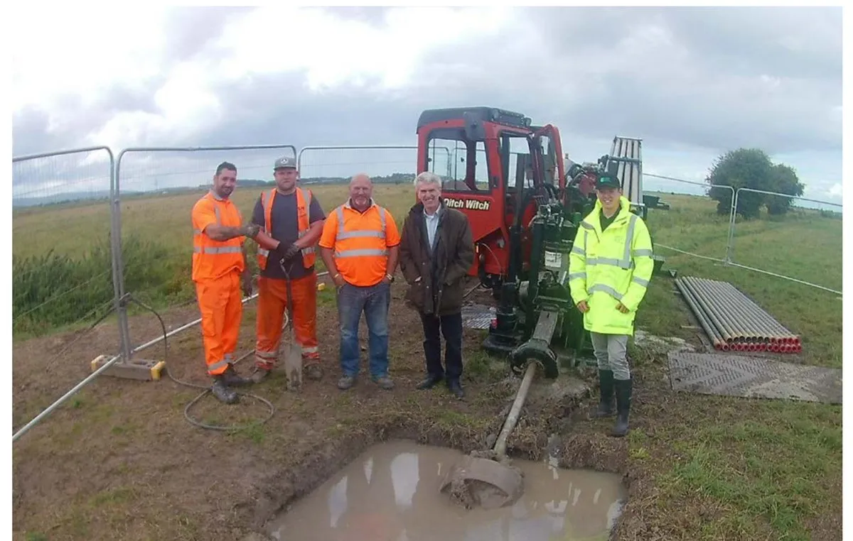
How we guided it is the part most people find surprising. Rather than an expensive downhole wireline or gyro system, we steered the bore with a DigiTrak F5+ walkover locator in Drill-To mode. The crossing was longer than that kit is really meant to reach, so at low tide we worked a small boat out onto the mud flats on each bank to pick the signal up from out over the water, held the depth we needed, and let the middle section run unguided across the river. Left-to-right accuracy matters little mid-river, so that was a sensible trade, and the gentle curve on the as-built line is the result of guiding it this way.
Bringing in a wireline or gyro guidance system would have cost around £20,000, for pinpoint accuracy this crossing simply did not need. Leaving it out saved the client that money outright. It is the sort of call that comes from having drilled a lot of rivers and knowing where the cost is worth paying and where it is not.
From start to finish, the pilot bore began on the Tuesday and the pipe was in by the Friday, about four days on a crossing most people assume would take weeks. At no point did anything go into the river. No cofferdam, no dredging, no in-channel works, which is exactly what a site like this needs.
Why it mattered
Pawlett Hams is not ordinary farmland. It is 397 hectares of rare coastal grazing marsh and forms part of the Bridgwater Bay Site of Special Scientific Interest, notified at European and international level. Its network of wildlife-rich ditches and rhynes supports water voles, rare plants and insects, and the marsh is vital winter habitat for migratory birds such as curlew, shelduck, dunlin and redshank.
Fresh water keeps those ditches stock-proof and the habitat healthy, so getting the supply back mattered well beyond the farm gate. Because the new main sits several metres below the riverbed, out of reach of the tides and scour that destroyed the old one, the restored supply is expected to serve the area for at least the next 50 years. The river crossing was the headline, but not the whole job. Alongside it we drilled across the fields and installed around 200 metres of gravity drainage, tying the ditch network together and balancing the water levels between the ditches on each side.
The people closest to the site summed up why it was worth doing. Once complete, the project drew warm words from those responsible for the marsh.
"We are delighted to see the project completed. Once the pipeline delivers freshwater to the area, it should quickly make the ditches stock-proof. This will provide drinking water for grazing animals, as well as improved habitat for the plants and animals that live there."
The outcome
A 252 metre water main installed under a tidal river, through clay and rock, on budget and without a single works in the river or across the protected marsh. The Hams have their freshwater back, and a supply built to last half a century. It is the kind of crossing that looks impossible from the bank and turns out to be exactly what directional drilling is built for.
Questions answered
Yes, and that is exactly what directional drilling is for. At Pawlett Hams we drilled a 252m water main clean under the tidal River Parrett, around 5 metres beneath the riverbed, with a launch pit on one bank and a reception pit on the other. Nothing went in the river itself, no cofferdam, no dredging, no in-channel works. The riverbed, the banks and the tidal flow were left untouched while the pipe was steered through the ground underneath. That is a big part of why drilling suits river and estuary crossings, especially on protected sites.
The Pawlett Hams crossing was 252m bank to bank, which made it one of the longest pipelines drilled under a river in the South West at the time. Length on its own is rarely the limit. What really decides a river crossing is the ground, the pipe diameter and the room to set out a launch and a reception pit on each bank. Send us the survey and we will tell you honestly whether your crossing can be drilled in one shot. See our horizontal directional drilling service for how a crossing like this is planned.
Yes. The pilot bore at Pawlett Hams went through a mixture of clay and rock beneath the estuary. We steer through mixed and rock ground regularly, using tooling matched to the conditions rather than fluid-hungry mud motors. Where a crossing is in harder rock we have a dedicated approach for it, set out on our rock directional drilling page.
Yes. Pawlett Hams is 397 hectares of rare coastal grazing marsh and forms part of the Bridgwater Bay Site of Special Scientific Interest, a habitat for water voles, rare plants and large numbers of migratory water birds. Keeping the work to a single small pit on each bank, with no works in the river or across the marsh, is what made the crossing acceptable on a site like that. Trenchless methods are often the only way to get a service across protected ground without damaging it.
On a tidal river that is wide, salty and protected, an open-cut trench or a pipe bridge was never realistic. The old pipe had already been destroyed by high tides. Drilling puts the new main several metres below the riverbed, out of reach of the same tides and scour, in a single continuous length with no joints under the river. It is the solution that lasts, which is why the new supply is expected to serve the area for at least the next 50 years.
Related services
The steered method behind this crossing: pipes and ducts installed under rivers, roads and obstacles in one continuous length.
View →Steering a bore through mixed ground and rock, as under the River Parrett, with tooling matched to the conditions.
View →Gravity and water-management pipework installed trenchlessly, including the follow-on gravity drainage on this scheme.
View →Send us your survey and levels. If your crossing can be directional drilled, under a river, a road or protected ground, we'll tell you honestly, with the bore designed to last.